- Posts: 3497
- Thank you received: 307
WheremEye
Less
More
6 years 8 months ago #186071
by Roderick Smith
Replied by Roderick Smith on topic WheremEye
Not the Fitzroy development road. A different development road was another one from which I chickened out. Rain on blacksoil, and I had a 2wd, but was following the tracks of two other vehicles. Then came the marks of a three-point turn: it was an earlier vehicle which had chickened out, and I did too. Again, I went the long way around, on surfaced roads.
I confirmed Queensland earlier, when the entry had nominated central Queensland, so I'll confirm central too.
Roderick
I confirmed Queensland earlier, when the entry had nominated central Queensland, so I'll confirm central too.
Roderick
Please Log in to join the conversation.
Less
More
- Posts: 3497
- Thank you received: 307
6 years 8 months ago #186098
by Roderick Smith
Replied by Roderick Smith on topic WheremEye
A more-substantial clue. The dirt road went through a set of railway stations, which is why I set out that way. The highway went the long way round.
Roderick
Roderick
Please Log in to join the conversation.
Less
More
- Posts: 295
- Thank you received: 97
6 years 8 months ago #186109
by Dodgeydude
Many useful things fall off trucks
Replied by Dodgeydude on topic WheremEye
another guess then ...Blackwater to Tieri area goes through some old mine sites with rail access and is near Fitzroy development Road
Many useful things fall off trucks
Please Log in to join the conversation.
Less
More
- Posts: 3497
- Thank you received: 307
6 years 8 months ago #186112
by Roderick Smith
Replied by Roderick Smith on topic WheremEye
I knew that it wouldn't be easy: not Blackwater - Tieri or Mt Isa - Duchess.
I did once drive through Landsborough Hwy at night, before it was sealed. The ruts were so deep that I was bottoming my Holden HK. It was easier to drive along the maintenance track alongside the power / phone lines.
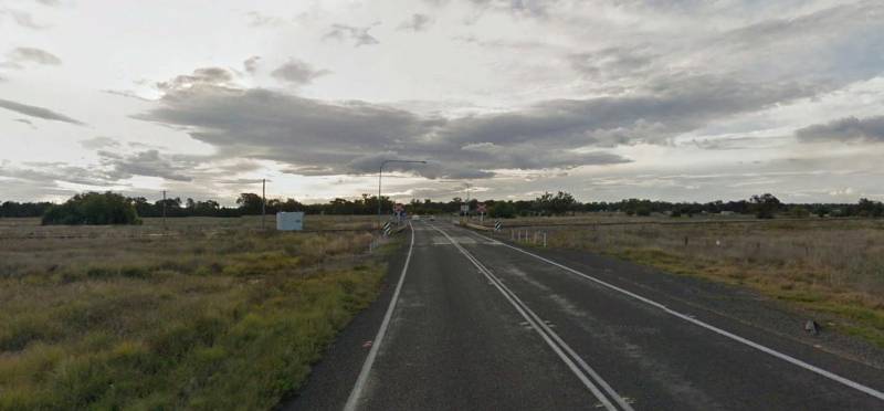
The quiz photo is fairly old. Since then, the highway has been relocated to follow this route; the earlier highway is now a local road.
Roderick.
I did once drive through Landsborough Hwy at night, before it was sealed. The ruts were so deep that I was bottoming my Holden HK. It was easier to drive along the maintenance track alongside the power / phone lines.
The quiz photo is fairly old. Since then, the highway has been relocated to follow this route; the earlier highway is now a local road.
Roderick.
Please Log in to join the conversation.
- John V
Less
More
- Posts: 3497
- Thank you received: 307
6 years 8 months ago #186126
by Roderick Smith
Replied by Roderick Smith on topic WheremEye
Not the Surat development road either.
Although the towns on the dirt bit were minor, they were between major places, which is what justified relocating the highway to this shorter route (matching the railway). I don't know how much of the dirt was reengineered, or if the new was built beside the old.
Roderick.
Although the towns on the dirt bit were minor, they were between major places, which is what justified relocating the highway to this shorter route (matching the railway). I don't know how much of the dirt was reengineered, or if the new was built beside the old.
Roderick.
Please Log in to join the conversation.
Less
More
- Posts: 3497
- Thank you received: 307
6 years 8 months ago #186132
by Roderick Smith
Replied by Roderick Smith on topic WheremEye
Yes, the old Marlborough - Sarina, Sun.31.8.75. It was shorter than the Bruce Hwy route, which could be why the warning sign was erected: surfaced beats short. Now Bruce Hwy runs this way, and the former highway is the old route.
Hopefully eerfree can come up with a good one.
Roderick
Hopefully eerfree can come up with a good one.
Roderick
Please Log in to join the conversation.
6 years 8 months ago #186135
by eerfree
Bob,
I do not know how I got over the hill without ever getting to the top.
Some scary stuff happened on that old route, Murders and crashes a lot of people were glad when it was bypassed, several old servos and businesses that shut down due to lack of traffic does not help.
This one is further South
This one is further South
Bob,
I do not know how I got over the hill without ever getting to the top.
Please Log in to join the conversation.
Time to create page: 1.018 seconds