- Posts: 3497
- Thank you received: 307
WheremEye
Less
More
3 years 2 days ago #221807
by Roderick Smith
Replied by Roderick Smith on topic WheremEye
Yes, Katherine River at Katherine (NT), carrying Stuart Hwy and the original North Australia Railway.
I had crossed by train twice in previous days. This bus ride was Darwin to Alice Springs, connecting with the original Ghan.
When the highway became a WWII supply line, a low-level single-lane concrete bridge & weir was built slightly downstream. It survives, for local traffic.
The decking on the railway bridge was used only when the other was flooded.
My photo was September 1974, which was not wet season.
The railway was closed around 1976.
That bridge has survived as a pedestrian bridge, viewable from the high-level road bridge. IIRC it is 17 m above the river bed. Two recent floods have reached 19 m.
The bridge was built in the mid 1920s, when the railway was being extended southwards. It was designed to carry standard-gauge.
However, when the sg line to Darwin was being built, it used a new bridge further downstream.
www.katherinemuseum.com/our-town/the-gallon-licence-store-2
I have photos of most of Australia's combined road & rail bridges. Two were demolished before I was a photographer, and a few had lost the railway before I got a photo. One is newer than my most-recent visit to the location.
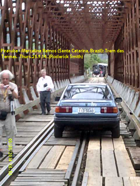
Enclosed: a photo of one in Brazil.
The usual prize to Gryphon.
Roderick
140925Th-DSCF0150-PiratubaBrazil-TremDasTermas-RSmith-ss.jpg
I had crossed by train twice in previous days. This bus ride was Darwin to Alice Springs, connecting with the original Ghan.
When the highway became a WWII supply line, a low-level single-lane concrete bridge & weir was built slightly downstream. It survives, for local traffic.
The decking on the railway bridge was used only when the other was flooded.
My photo was September 1974, which was not wet season.
The railway was closed around 1976.
That bridge has survived as a pedestrian bridge, viewable from the high-level road bridge. IIRC it is 17 m above the river bed. Two recent floods have reached 19 m.
The bridge was built in the mid 1920s, when the railway was being extended southwards. It was designed to carry standard-gauge.
However, when the sg line to Darwin was being built, it used a new bridge further downstream.
www.katherinemuseum.com/our-town/the-gallon-licence-store-2
I have photos of most of Australia's combined road & rail bridges. Two were demolished before I was a photographer, and a few had lost the railway before I got a photo. One is newer than my most-recent visit to the location.
Enclosed: a photo of one in Brazil.
The usual prize to Gryphon.
Roderick
140925Th-DSCF0150-PiratubaBrazil-TremDasTermas-RSmith-ss.jpg
Please Log in to join the conversation.
3 years 1 day ago - 3 years 1 day ago #221813
by Gryphon
Hi,
this is what it looks like these days so it made it a bit tricky to match it to Rodericks picture with the wood deck and the barriers missing.
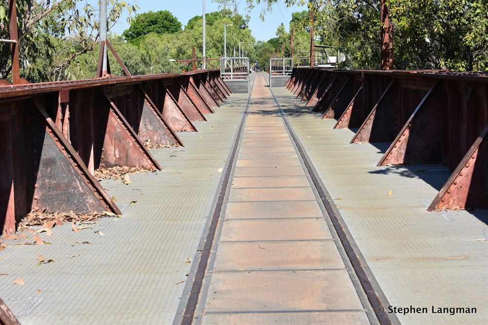
www.exploroz.com/places/113689/nt+kather...bridge-river-lookout
I recognised the flora out of the right hand side window as being top end, NT or WA, so it was just a case of searching google for images of road rail bridges in the top end some where.")
https://www.hcvc.com.au/forum/attachment/22705
Terry
this is what it looks like these days so it made it a bit tricky to match it to Rodericks picture with the wood deck and the barriers missing.
www.exploroz.com/places/113689/nt+kather...bridge-river-lookout
I recognised the flora out of the right hand side window as being top end, NT or WA, so it was just a case of searching google for images of road rail bridges in the top end some where.
https://www.hcvc.com.au/forum/attachment/22705
Terry
Last edit: 3 years 1 day ago by Gryphon.
The following user(s) said Thank You: Roderick Smith
Please Log in to join the conversation.
Less
More
- Posts: 3497
- Thank you received: 307
2 years 11 months ago #221928
by Roderick Smith
Replied by Roderick Smith on topic WheremEye
4 days. Are you having trouble finding a photo?
I have two on standby, but anyone can grab a Google Earth view, crop and post.
Roderick
I have two on standby, but anyone can grab a Google Earth view, crop and post.
Roderick
Please Log in to join the conversation.
Less
More
- Posts: 3497
- Thank you received: 307
2 years 11 months ago #221942
by Roderick Smith
Replied by Roderick Smith on topic WheremEye
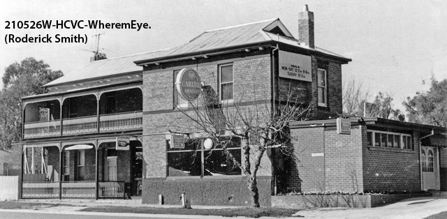
To keep the pace up, have the easier of my two standby photos.
Most of my road-landmark photos will be pubs or bridges; photos with other clues aren't scanned.
Roderick
210526W-HCVC-WheremEye-RSmith-ss.jpg
Most of my road-landmark photos will be pubs or bridges; photos with other clues aren't scanned.
Roderick
210526W-HCVC-WheremEye-RSmith-ss.jpg
Please Log in to join the conversation.
Less
More
- Posts: 3497
- Thank you received: 307
2 years 11 months ago #221971
by Roderick Smith
Replied by Roderick Smith on topic WheremEye
I picked this one because many members will have driven past it.
Roderick
Roderick
Please Log in to join the conversation.
Less
More
- Posts: 3497
- Thank you received: 307
2 years 11 months ago #221979
by Roderick Smith
Replied by Roderick Smith on topic WheremEye
Not Goulburn Valley Highway.
Roderick
Roderick
Please Log in to join the conversation.
2 years 11 months ago #221983
by hayseed
It does look familiar Mate...But Buggered if I can Place It..!
"Be who you are and say what you feel...
Because those that matter...
don't mind...
And those that mind....
don't matter." -
Reckon your wrong Seed
Looks fimiliar
It does look familiar Mate...But Buggered if I can Place It..!
"Be who you are and say what you feel...
Because those that matter...
don't mind...
And those that mind....
don't matter." -
Please Log in to join the conversation.
Time to create page: 0.599 seconds