- Posts: 295
- Thank you received: 97
WheremEye
Less
More
Less
More
- Posts: 295
- Thank you received: 97
4 years 3 months ago #205310
by Dodgeydude
Many useful things fall off trucks
Replied by Dodgeydude on topic WheremEye
The trees at Fortescue River look familiar as well
Many useful things fall off trucks
Please Log in to join the conversation.
Less
More
- Posts: 3497
- Thank you received: 307
4 years 3 months ago #205330
by Roderick Smith
Replied by Roderick Smith on topic WheremEye
Not Pardoo, which is north of Port Hedland.
So far the best entries are Carnarvon and Minilya, although neither is the name in my notepad.
I am having trouble getting all prospects to show at the same time on Google Earth.
Also the km distances in the photo don't match the ones which I wrote, but the photo ones are fuzzy.
I'll do more homework later this afternoon, and put up a clincher clue.
Please Log in to join the conversation.
Less
More
- Posts: 3497
- Thank you received: 307
4 years 3 months ago #205336
by Roderick Smith
Replied by Roderick Smith on topic WheremEye
The photo was Fri.27.8.82.
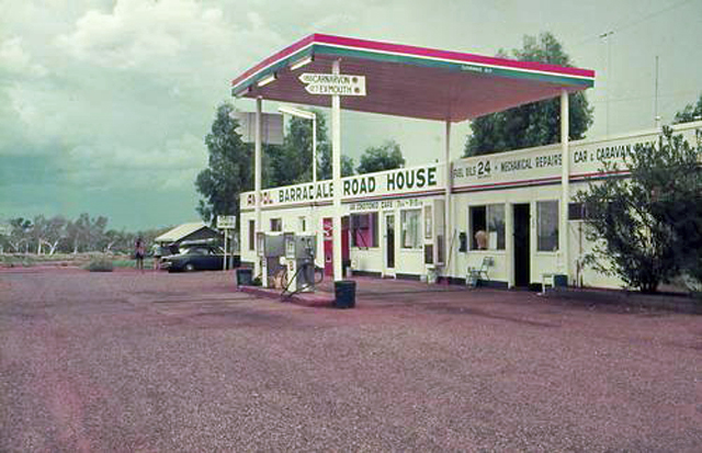
The breakfast stop was at Barradale, which I noted as 315 km from Carnarvon and 203 km from Exmouth.
That was 6.50-7.40. The Onslow turnoff at 853 is consistent with Barradale.
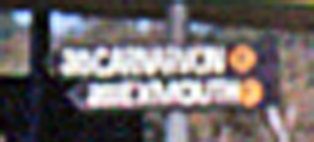
However, the sign in the photo looks like 30 km from Carnavon, and hardly three digits to Exmouth.
The timetable showed Carnarvon at 3.05-35; Minilya at 5.10; Barradale 6.50-7.35.
There is no guarantee that the photo was taken at breakfast.
Google Earth of Minilya today shows no large sun shelters. What would the sun have been like at 5.10 in August?
Nanutarra roadhouse was BP.
There was Mardie roadhouse 10.30-45. That is Fortescue River, but is BP today, the verandah is also quite different.
I was alighting at Dampier, at about 11.50.
The photo before was in Perth on the preceding day; the photo after was in Dampier later in the afternoon.
The Carnavon and Exmouth sign, and the background, and Google Earth knock the Eneabba dinner stop.
820827F-TA05b-Barradale-AnsettPioneer-MCIx-RSmith-sss.jpg
Yet to come: photos of the defunct Ampol Barradale roadhouse, demolished when the highway was deviated and surfaced. Today it is a camping spot.
Roderick
The breakfast stop was at Barradale, which I noted as 315 km from Carnarvon and 203 km from Exmouth.
That was 6.50-7.40. The Onslow turnoff at 853 is consistent with Barradale.
However, the sign in the photo looks like 30 km from Carnavon, and hardly three digits to Exmouth.
The timetable showed Carnarvon at 3.05-35; Minilya at 5.10; Barradale 6.50-7.35.
There is no guarantee that the photo was taken at breakfast.
Google Earth of Minilya today shows no large sun shelters. What would the sun have been like at 5.10 in August?
Nanutarra roadhouse was BP.
There was Mardie roadhouse 10.30-45. That is Fortescue River, but is BP today, the verandah is also quite different.
I was alighting at Dampier, at about 11.50.
The photo before was in Perth on the preceding day; the photo after was in Dampier later in the afternoon.
The Carnavon and Exmouth sign, and the background, and Google Earth knock the Eneabba dinner stop.
820827F-TA05b-Barradale-AnsettPioneer-MCIx-RSmith-sss.jpg
Yet to come: photos of the defunct Ampol Barradale roadhouse, demolished when the highway was deviated and surfaced. Today it is a camping spot.
Roderick
Please Log in to join the conversation.
4 years 3 months ago #205337
by wouldyou
Mobil left WA some time back in a deal with BP, When in Carnarvon three years ago I seem to remember shades as in the picture at a Shell outlet that was abandoned due to flooding, there has been a lot of work done to guard against this in the future. Google now shows the site as Shell bulk outlet.
David.
David.
Please Log in to join the conversation.
Less
More
- Posts: 3497
- Thank you received: 307
4 years 3 months ago - 4 years 3 months ago #205354
by Roderick Smith
Replied by Roderick Smith on topic WheremEye
Not Sandfire (which is north of Port Hedland).
The problem with this WhereEye is that I don't know where I was.
The photo is between Perth and Dampier.
The timetable showed a breakfast stop at Barradale.
The times when we stopped matched that, and the time to the Onslow turnoff matched the correct distance.
The distance signs in my photo show Exmouth and Carnarvon, which wouldn't be the ones chosen at Fortescue River.
The frustration is that I cannot find anything to match on Google Earth today.
Here are the photos of the old Ampol roadhouse at Barradale, which I found on a web search:
Barradale-Ampol.roadhouse-a.jpg
Barradale-roadhouse-b.jpg
That one was built in 1968 [ www.flickr.com/photos/juliawoolgar/6297699858 ]
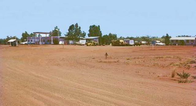
It was demolished when the highway was diverted and surfaced. Today, the site is a rest area:
Yannarie River Barradale Rest Area is a free overnighter on the eastern bank of Yannarie River, just west of the Barradale Roadhouse.
More hunting:
- 'An archive I have access to says in was closed by owner Shell in 1992 due to a downturn in business. Also said the sealing of the final section of Great Northern Highway between Newman and Port Hedland in 1990 had an effect.
- destroyed by fire.
My conclusion is that there were two roadhouses, and both have gone, and my photo really was the Barradale breakfast stop. Minilya was too early and too brief.
Fortescue River is the only other possible contender. Does the angle of sun match 7.00 or 10.00?
Dodgeydude covered the closest two prospects, so grab the beer and provide the next challenge.
Roderick
The problem with this WhereEye is that I don't know where I was.
The photo is between Perth and Dampier.
The timetable showed a breakfast stop at Barradale.
The times when we stopped matched that, and the time to the Onslow turnoff matched the correct distance.
The distance signs in my photo show Exmouth and Carnarvon, which wouldn't be the ones chosen at Fortescue River.
The frustration is that I cannot find anything to match on Google Earth today.
Here are the photos of the old Ampol roadhouse at Barradale, which I found on a web search:
Barradale-Ampol.roadhouse-a.jpg
Barradale-roadhouse-b.jpg
That one was built in 1968 [ www.flickr.com/photos/juliawoolgar/6297699858 ]
It was demolished when the highway was diverted and surfaced. Today, the site is a rest area:
Yannarie River Barradale Rest Area is a free overnighter on the eastern bank of Yannarie River, just west of the Barradale Roadhouse.
More hunting:
- 'An archive I have access to says in was closed by owner Shell in 1992 due to a downturn in business. Also said the sealing of the final section of Great Northern Highway between Newman and Port Hedland in 1990 had an effect.
- destroyed by fire.
My conclusion is that there were two roadhouses, and both have gone, and my photo really was the Barradale breakfast stop. Minilya was too early and too brief.
Fortescue River is the only other possible contender. Does the angle of sun match 7.00 or 10.00?
Dodgeydude covered the closest two prospects, so grab the beer and provide the next challenge.
Roderick
Last edit: 4 years 3 months ago by Roderick Smith. Reason: Alert Dodgedude for the next turn.
Please Log in to join the conversation.
Less
More
- Posts: 295
- Thank you received: 97
4 years 3 months ago #205413
by Dodgeydude
Many useful things fall off trucks
Replied by Dodgeydude on topic WheremEye
My apologies Gentlemen. Although I have traveled a bit I never had a camera, just another of lifes regrets. I do have some great memories though and I have the advantage of bending them a little to suit rather than having hard evidence. ") . For the last one I was sure I had called in there on the way to the dog fence, DOH.
. For the last one I was sure I had called in there on the way to the dog fence, DOH.
So if you have a photo, put it up. I enjoy the hunt, although the standard has been raised when the poster does not know the answer :ohmy: :lol: :silly: :woohoo:
. For the last one I was sure I had called in there on the way to the dog fence, DOH.So if you have a photo, put it up. I enjoy the hunt, although the standard has been raised when the poster does not know the answer
:ohmy: :lol: :silly: :woohoo: Many useful things fall off trucks
Please Log in to join the conversation.
Time to create page: 0.615 seconds