- Posts: 3497
- Thank you received: 307
WheremEye
Less
More
2 years 9 months ago - 2 years 9 months ago #223735
by Roderick Smith
Replied by Roderick Smith on topic WheremEye
For those not Victorian, that is a Melbourne scene.
I do have one ready to roll, which I regard as easy. I will wait until after dinner so that more people get the chance to grab.
There is a lot more history to this. All of that was mudflats, and the Yarra went roughly where today's Footscray Rd (and future tollway) go. Hence the name Coode Island for the restricted chemical part of the port.
The Coode scheme of the 1880s created what we know today. The Yarra became a dredged canal, with provision for several docks leading north from it, and several south, and several piers into Hobsons Bay. Of the north lot, Victoria Dock came at the time, then Appleton Dock in the 1950s or 60s, then Swanson Dock ~20 years later. Fewer than planned, but larger to match the changing size of ships, and containerisation. None of the south lot came. We got Fisherman's Bend Aerodrome, then a lot of industry. Station Pier (replacing Railway Pier), Princes Pier and Webb Dock were the only new ones built for the bayside plan.
The original road to Footscray was the extension of Dudley St, crossing the mouth of Moonee Ponds Creek (on a bascule bridge?), then angling back to the swing bridge at Footscray (not replaced until the early 1960s). What we know as Footscray Rd was New Footscray Rd for years, built on reclaimed land. Has Swingbridge Motors survived? For years, people wondered about how its name arose. A block of flats on the north side of the railway near South Kensington was once Bayview Hotel. When built, it would have had a view of the mudflats.
I'm not sure when Dynon Rd was built, but it is also on reclaimed land.
Coode was the major dock consultant worldwide in that era. His services were expensive; his scheme was expensive. Victoria was wealthy, and was building for the future, and the scheme has fulfilled it vision.
en.wikipedia.org/wiki/John_Coode_(engineer)
Roderick
Last edit: 2 years 9 months ago by Roderick Smith. Reason: added more
Please Log in to join the conversation.
Less
More
- Posts: 3497
- Thank you received: 307
2 years 9 months ago #223742
by Roderick Smith
Replied by Roderick Smith on topic WheremEye
210723F-HCVC-WheremEye-RSmith.jpg
Roderick, posting at 19.03 on Friday
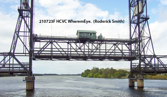
Roderick, posting at 19.03 on Friday
Please Log in to join the conversation.
2 years 9 months ago - 2 years 9 months ago #223743
by Swishy
OF ALL THE THINGS EYE MISS ................. EYE MISS MY MIND THE MOST
There's more WORTH in KENWORTH
GranPa Head n East Dynon Rd rail bridge @ Nth Melb Station .. NR Mack with static sheeps foot roller (cirrca mid 50's

cya
cya
OF ALL THE THINGS EYE MISS ................. EYE MISS MY MIND THE MOST
There's more WORTH in KENWORTH
Last edit: 2 years 9 months ago by Swishy.
The following user(s) said Thank You: PaulFH, Roderick Smith
Please Log in to join the conversation.
Less
More
- Posts: 3497
- Thank you received: 307
2 years 9 months ago #223759
by Roderick Smith
Replied by Roderick Smith on topic WheremEye
The station is 1880s, and that bridge must be the same. The current bridge is ~1970s, and the old one became pedestrian access to the station. Now the access is via a garishly-mismatched concourse at the city end of the platforms.
Please Log in to join the conversation.
Less
More
- Posts: 3497
- Thank you received: 307
2 years 9 months ago #223760
by Roderick Smith
Replied by Roderick Smith on topic WheremEye
The station is 1880s, and that bridge must be the same. The current bridge is ~1970s, and the old one became pedestrian access to the station. Now the access is via a garishly-mismatched concourse at the city end of the platforms.
Please Log in to join the conversation.
2 years 9 months ago #223778
by fxs80
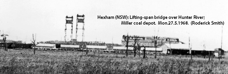
1939 D2
With much thanks to Mrs Google (she who knows all)
The Hexham Bridge is a pair of road bridges that carry the Pacific Highway across the Hunter River from Tarro to Tomago in the Hunter Region of New South Wales, Australia. It comprises two separate structures; a steel truss bridge opened in 1952 and a concrete opened in 1987. Wikipedia
The Hexham Bridge is a pair of road bridges that carry the Pacific Highway across the Hunter River from Tarro to Tomago in the Hunter Region of New South Wales, Australia. It comprises two separate structures; a steel truss bridge opened in 1952 and a concrete opened in 1987. Wikipedia
1939 D2
Please Log in to join the conversation.
2 years 9 months ago #223786
by cobbadog
Cheers Cobba & Cobbarette
Coopernook, The Centre of our Universe
Working on more play time.
That area is commonly called Hexham just north of Newcastle. It is still a bottle neck until they decide to connect the end of the motorway to the new concrete bridge. From memory it has not been done because the road has to cross a swamp and this swamp has some little green froggies in it and they dont want to upset the locals.
Cheers Cobba & Cobbarette
Coopernook, The Centre of our Universe
Working on more play time.
Please Log in to join the conversation.
Less
More
- Posts: 3497
- Thank you received: 307
2 years 9 months ago #223787
by Roderick Smith
Replied by Roderick Smith on topic WheremEye
Yes, Hunter River at Hexham, an area renowned for giant mosquitos.
I picked this one to exclude the second bridge (which is upstream, behind me). I was on a charter cruise with Australian Ferry Society. As with all technical hobbies: we have similar passions, just different equipment.
My earliest photo of this bridge predated the concrete extra: I was at the interchange yard for Richmond Vale colliery and NSWR, when RVR was still using steam locos cascaded from WWI.
The reward and baton to fxs80. Perhaps a Resch (pronounced retch?)
Roderick
The following user(s) said Thank You: cobbadog
Please Log in to join the conversation.
2 years 9 months ago #223799
by cobbadog
Cheers Cobba & Cobbarette
Coopernook, The Centre of our Universe
Working on more play time.
We have been to the Richmondvale Railway Museum when they run the Cranky Handle Rally. A great place and wonderful setting amongst the trees. Got a private tour of the colliery one time then down to the big carriage shed where the Cadillac railcar was. Been there before and after the bushfires. Was planning on going again and only just heard recently that this years rally is cancelled like so many others.
Cheers Cobba & Cobbarette
Coopernook, The Centre of our Universe
Working on more play time.
The following user(s) said Thank You: Roderick Smith
Please Log in to join the conversation.
Time to create page: 0.763 seconds